Turning Maps into Lifelines: The Aftermath of The Turkey/Syria Earthquake
 Anashie Mildred Andokie
What is OpenStreetMap (OSM)?
OpenStreetMap (OSM) is a collaborative mapping project that creates a free, editable map of the world. It is an open data source, allowing anyone to use and contribute to its information. Much like an atlas provides geographical data, OSM offers detailed mapping information that can be updated in real-time by volunteers. This means that as environments change, OSM can reflect those changes quickly. The data is invaluable for various applications, including disaster response, urban planning, and navigation, enabling users to analyze cities and coordinate efforts effectively during emergencies
In recent times, OpenStreetMap data have been beneficial in transforming the way we navigate, respond to emergencies, and ultimately save lives during disasters and in general. OpenStreetMap offers information on details at a level that seemed impossible, allowing us to analyze cities on a block-by-block level and uncover insights into urban layouts and connectivity across the globe. The power of OSM data, combined with the dedication of individuals and organizations worldwide, can transform the way we approach disaster management, ensuring that we are better equipped to face the challenges ahead.
We are going to explore a bit of this below;
. . .
The Power of OpenStreetMap Data in response to the Turkey and Syria Earthquake for Disaster Relief.
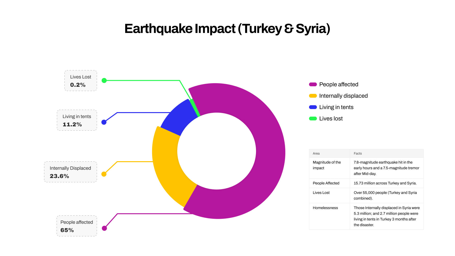
Each year, disasters around the world kill nearly 100,000 and affect or displace 200 million people. The disaster that occurred on the 6th of February 2023 in Turkey and Syria stands out as one of the most severe calamities witnessed this century. Millions of internally displaced persons and over 55,000 people in southern Turkey and northern Syria lost their lives.

In the aftermath, OpenStreetMap (OSM) played a crucial role in disaster response, recovery, and climate-smart reconstruction efforts. Mapping tools allowed for effective damage assessment, enabling organizations to visualize the impact on infrastructure, housing, and services. Local communities and volunteers contributed to mapping efforts, providing on the ground insights into the damage and identifying needs, such as shelter, food, and medical assistance. Without this data, efficiently coordinating the movement of goods, resources, and personnel in the aftermath of a major earthquake would be significantly more challenging.
Some Components of the OSM dataset/Key features of the OSM dataset
OpenStreetMap is continuously evolving, enhancing its extensive global reach. Its dataset with a wide variety of features makes it an essential tool for developing detailed maps and navigation systems worldwide. During disaster response and climate change and reconstruction, OSM data set provides essential information on;
Building footprint
Land use data
Points of interest
Classified road system
Location of trees
Water points
Infrastructure
Location of infrastructure such as bridges, dams, etc.
Social infrastructure
Rivers & water bodies
Other Use Cases
These projects are stand-out examples of how OpenStreetMap data/StoryMaps are impacted Disaster management and Climate Projects
Tracking Hurricane Maria’s Impact on Puerto Rico: Hurricane Maria impacted Puerto Rico in 2017, the Humanitarian OpenStreetMap Team (HOT) mobilized quickly, creating detailed maps to support first responders by pinpointing critical infrastructure, streets, and neighborhoods for rescue and relief operations. Volunteers Mapping Post-Hurricane Puerto Rico
Storm Daniel- Storm Daniel was regarded by researchers as the deadliest single flood event to hit Africa in recorded history, with its death toll of over 5000 surpassing flooding in Algeria that killed 3,000 in 1927. The storm, which struck northeastern Libya in September 2023, caused significant infrastructure damage. In response, the Humanitarian OpenStreetMap Team (HOT) provided up-to-date geospatial data crucial for disaster relief including, mapping flood-damaged roads, bridges, and buildings to help humanitarian organizations identify safe routes, locate isolated communities, and coordinate resources effectively.
Image depicting the impact of Flooding caused by Storm Daniel in Libya [Paul H.]. Pexels
Looking into the future
Incorporating Vulnerability and Capacity Assessments (VCAs) into rehabilitation initiatives is vital as it involves grasping the requirements of those impacted and formulating solutions that connect with them authentically. To guarantee that our endeavors, in sectors such as water supply and sanitation and healthcare are not quick fixes but sustainable remedies, for the long term it is imperative to undertake climate risk evaluations before executing any interventions. By utilizing OpenStreetMap data and integrating some climate smart recovery factors into planning processes for cities and towns so that we can construct communities that not only bounce back from challenges but truly bloom and prosper over time.
As we look to the future – we need to continue making use of mapping technologies to enhance disaster response capabilities and foster resilient communities. The lessons learned from this tragedy can guide us in better preparing for and responding to future disasters, ultimately saving lives and rebuilding hope in affected regions.
It is important to remember that behind each data point, there is a tremendous human effort from volunteers and organizations. Every single object that has been mapped so far, has had human eyes creating, modifying, or validating it. The effort continues and anyone can contribute to the map.
If you are a mapper who wants to get involved or you have never mapped before and would like to get started, visit our page to get started.
Join us in maximizing the power of open-source for humanitarian causes! You can make a difference, We all can make a difference.🎉
Subscribe to my newsletter
Read articles from Anashie Mildred Andokie directly inside your inbox. Subscribe to the newsletter, and don't miss out.
Written by
