Can Movies teach you Geospatial Tech?
 Aishwarya
🎬 Ever watched a film or documentary and thought:
“How did they track that missing person down?”
“Is that really a satellite image?”
Or even, “Could this actually happen in real life?”
If you’re just stepping into the world of geospatial technology, like I am, you might be surprised how often it's hiding in plain sight on screen. From climate crises and disaster response to military operations and urban surveillance—geospatial tools are the quiet powerhouse behind many stories.
In this article, I’ll walk you through a few standout films and documentaries that shed light on how geospatial software is used to solve real-world problems.
Documentaries that featured geospatial technology
MH370: The Plane That Disappeared (2023) - Netflix
In 2014, Malaysia Airlines Flight MH370 vanished from radar with 239 people on board. How does a modern airplane just disappear? Nearly a decade later, we still don’t have all the answers—but we do have an incredible story of how geospatial tools were used in the search.
This gripping docuseries humanizes the role of satellite data, ocean mapping, and geospatial analysis in a real-world crisis.
Here’s how geospatial technology played a key role:
Satellite “Handshake” Data: When radar and radio went silent, investigators relied on automated satellite signals (or “handshakes”) from Inmarsat to estimate the flight’s path.
Arc Mapping & Probability Models: Analysts used GIS to create arcs over the Indian Ocean based on time-stamped satellite pings—narrowing down where the aircraft might have crashed.
Ocean Drift Models: Scientists used ocean current simulations and satellite imagery to predict how debris could travel, leading to actual wreckage discoveries.
Crowdsourced Image Analysis: Platforms like Tomnod let the public scan satellite photos for debris—a rare blend of open-source intelligence and spatial crowdsourcing.
Curious to learn more? GeoScience Australia has released an article about the geological data behind the search for flight MH370.
Link to the article
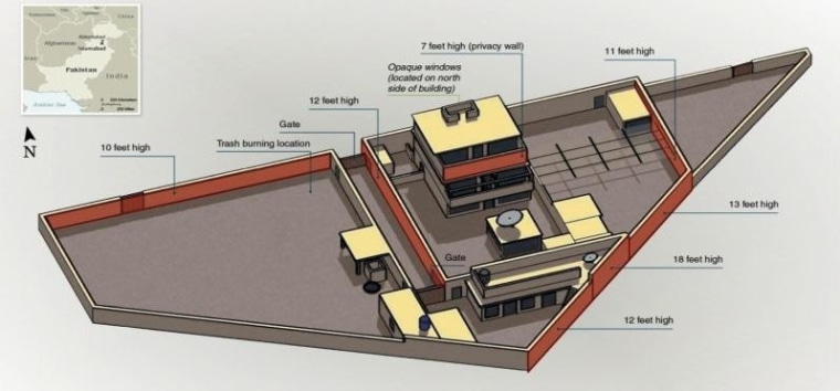
American Manhunt: Osama Bin Laden (2025)
“But the intelligence analysts didn’t have time to grieve or reflect. They had a mission at hand: to figure out who did this and stop them before the next attack.”
This three-part docuseries revisits the U.S. intelligence community’s hunt for Osama Bin Laden. Among its many revelations, it demonstrates how satellite imagery, spatial tracking, and remote sensing played critical roles in narrowing down his location.
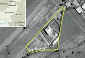
Intelligence teams observed a man pacing in a courtyard in Abbottabad, Pakistan. Using a method called mensuration, they measured the man’s shadow and matched it to Bin Laden’s known height—helping confirm his identity.
Other geospatial highlights:
High-resolution satellite images were used to analyze site history and monitor changes.
Military strategists used 3D terrain mapping and real-world simulations to rehearse every possible scenario before the raid.
Space-based military satellites ensured secure, real-time communication between field agents and command units.
It’s a vivid reminder that satellite imagery is more than just surveillance—it’s strategic insight.
Titan: The OceanGate Disaster (2025)
Unlike the other examples, the Titan submersible tragedy reveals what happens when geospatial tech is missing.
Because GPS doesn’t work deep underwater, the team relied on a clunky combination of tools:
Text-based messaging and Excel sheets were used to manually track location.
A Logitech F710 wireless game controller steered the sub.
The team used real-time monitoring (RTM) systems with acoustic sensors and strain gauges to detect hull stress—offering some insight but no location certainty.
This case exposed a chilling gap in deep-sea spatial tracking—highlighting the importance of developing robust geospatial systems for underwater navigation.
Top Gun: Maverick (2025)
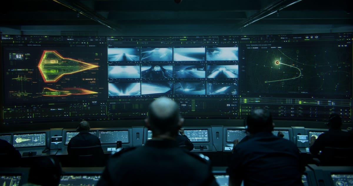
You probably didn’t go into Top Gun: Maverick expecting a geospatial masterclass—but it’s there, behind the adrenaline and dogfights. Top Gun: Maverick isn’t just a thrilling action film—it's also a subtle showcase of how geospatial technology powers modern military operations.
Pilots in the film navigate mountainous terrain at extreme speeds, avoid detection, and carry out a high-risk strike—all made possible by advanced geospatial simulation and intelligence.
What the film gets right about geospatial tech:
Terrain Avoidance Systems: Based on high-resolution satellite and LIDAR data, these simulations guide pilots through realistic flight paths and obstacle zones.
Mission Planning Software: Real-world tools like FalconView allow for mapping of threats, airspace, and terrain layers to design strategic routes.
GEOINT (Geospatial Intelligence): Targeting, surveillance, and mission rehearsal all depend on accurate satellite imagery and geospatial models.
For newcomers to the field, it’s a thrilling example of how critical spatial awareness and geographic data are to real-world problem-solving—especially when lives are on the line.
🧭 Why These Stories Matter?
Mainstream media doesn’t just entertain - it educates. It opens our eyes to the latest technologies and their adaptations of it. They demonstrate that GIS isn’t just for scientists. It’s for storytellers, strategists, city planners, investigators, climate activists and more. Watching them with a critical eye can help you recognise how geospatial tools influence the world - both in fiction and in real life.
🔍 Want to Dive Deeper?
Here’s are some activites you can explore:
Explore Esri StoryMaps: See how maps tell interactive stories
Download QGIS: open-source software and amazing for beginners
Use Google Earth Studio: For cinematic animations of real-world locations.
✍️ Coming Up Next
In Part 2, I’ll walk you through how to start using QGIS as a beginner. I’m also considering a follow-up with book recommendations for those curious about geospatial science and storytelling.
Would you be interested? Let me know in the comments! 🌍📽️
Resources used (in harvard citation):
NBC News. (n.d.). How satellites helped get Osama. [online] Available at: https://www.nbcnews.com/science/cosmic-log/how-satellites-helped-get-osama-flna6c10403193.
Netflix.com. (2025). Available at: https://www.netflix.com/tudum/articles/where-is-mh370.
Staff, T. (2025). American Manhunt Osama bin Laden Netflix Documentary Streaming Now. [online] Netflix Tudum. Available at: https://www.netflix.com/tudum/articles/american-manhunt-osama-bin-laden-release-date-news.
Subscribe to my newsletter
Read articles from Aishwarya directly inside your inbox. Subscribe to the newsletter, and don't miss out.
Written by
Aishwarya
Aishwarya
Hey there! I’m Aishwarya — part engineer, part educator, part explorer. Also: geospatial specialist, ex-data engineer, and social media manager at WomenDevsSG. From Python scripts to satellite maps—I turn data into stories and workflows into impact. Currently sharing, mentoring, and building in public. 🚀 Stick around for hands-on posts on automation, cloud, spatial data, and scaling knowledge through code. Let’s learn and grow together!